![]()
THE EAST FIELD OF LITTLE BOWDEN
![]()
![]()
![]()
![]()
![]()
![]()
For hundreds of years Little Bowden was a small agricultural village surrounded by three large open fields. Much of this land is now covered by new housing. The latest area for development has been the piece of land between the river Welland , Kettering Road and the old parish boundary. This area was covered by the East field, one of the three open fields of Little Bowden village.
Under the open field system of agriculture each field was worked on a three year rotation. One year peas and corn, the second year wheat and the third year the field was left fallow. The farmers in the village had their lands dispersed in strips evenly distributed throughout the parish. As time went on exchange and sale often resulted in several adjoining strips being in single ownership. The size of the strip varied but most common was the one rood land some 8 yards wide by 220 yards or one furlong long, supposedly as much as a team of oxen could plough in one day
The individual lands were grouped into furlongs and these
were perhaps reminiscent of the fields we have in our landscape today,
except there were no hedges. Boundaries between furlongs might only be
marked by a change in the direction in which land was ploughed or a strip of
grass called a balk. Although the furlongs have disappeared the memory of
them is retained in some of the new street names, Flaxland Close, Stinford
Leys , Long Brimley Close and Stablegate Way are all based on furlong names.
Stablegate Way or staple gate as it was originally named was an ancient road
which extended across the East field as a continuation of glebe Road. A gate
was the name for a road in areas under Scandinavian influence, whilst the
staple was a post marking the road. This road was still visible as a grassy
hollow in the field before housing development occurred.
This open field system of agriculture persisted until the
eighteenth century when the parish was enclosed and the land divided into
blocks and allocated to individuals who had previously had rights in the
open fields. It was at this time the hedgerows were planted to demarcate
each individuals holdings. Some of the larger allotments were subdivided and
also planted with hedges to create the fields which remained until recent
development began.
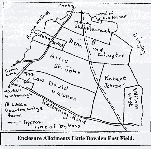
After the enclosure the first building on the land of the former East field was Little Bowden Lodge farm or Tithe farm as it was called initially.
This was probably completed within a few years of the enclosure the parish in 1780. The farmhouse was built on an eighty acre plot which had been allocated to the Dean and Chapter of Christ Church college Oxford, in lieu of the tithes they had previously received from the St. Mary's lands within the parish. Christ Church also held lands in Great Bowden and together with the Little Bowden lands was known as the Great Bowden Rectory Estate. This property was finally sold in 1926 when the Little Bowden land was purchased by the Moseley family. The far buildings remain to this day although now they are on the other side of the by-pass.
Development of the old East field was delayed until new sewers were laid in the late nineteen eighties, but progress since has been rapid and now the land as far as the A6 by-pass has been lost to agriculture.
Pam Aucott